Land use, land cover and water quality
Project title: “A Pilot Study In Improving The Health of At-Risk Western Australian Estuaries: Assessing The Relationship Between On-Land Water Use and Estuarine Health.”
Funded by: Western Australian Satellite Technology and Applications Consortium (WASTAC) Small Grants Scheme
Researchers: David Antoine (PI), Eriita Jones, Kieryn Kilminster (DWER)
Period: 2020-2022 (project poised to start 1st October 2020)
Synopsis:
The water quality and biological populations within estuaries can be strongly impacted by surrounding land use.
Estuarine health can be negatively affected by physical and chemical inputs from surrounding agricultural, industrial and urban activities, particularly after significant rainfall discharge and runoff events.
A number of Western Australian (WA) estuaries are deemed at risk due to inputs from surrounding agricultural fertiliser use leading to algal blooms and declining seagrass populations.
This research will examine four WA estuaries across the state to decipher the impact of land-use and land-cover (LULC) water use surrounding the estuaries, and the estuary water quality.
The data from Landsat 8, Sentinel 2, MODIS Terra, and Sentinel 3 OLCI will be harnessed, along with machine learning data fusion algorithms, to derive high frequency measurements of LULC water usage (mL/day), estuary phytoplankton content, total suspend matter and organic particle concentration to uncover the trends in estuary health over time.
Through this research, and partnership with the Department of Water and Environmental Regulation (DWER), we will assist with identifying the LULC sources of threats to estuary ecosystem health and water quality, including the impacts of increased irrigation and agricultural intensification, and contribute actionable data products to DWER to assist with decision making around future estuarine management.
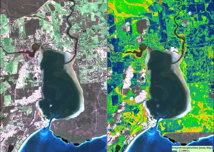
An example is shown below of a Sentinel2 image Oyster Harbour estuary, Albany, Western Australia.